
Matjiesfontein Walks: Perdekloof
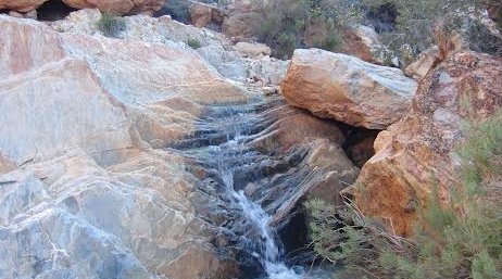
A spectacular walk in the Witteberg Mountains that will see you rising in altitude about 175 metres—with the reward of the cooling plunge pools at its end.
For even more adventure, make some time to go view the Matjiesfontein Geodesy Observatory (MGO) too.
Time: Around 2 hours each way (this can be shorted by driving, you’ll need a high ground clearance vehicle).
*The pools may not always be full enough for swimming, check at reception before your hike.
Directions:
Turn right out of The Lord Milner. At the road bend continue forward on the dirt road and cross the railway line. The gravel road bears left back towards the station and then right to the locked farm gate. Proceed through the gate and continue straight ahead following the jeep track up into the Witeberg.
After crossing two river beds with protective embankments, the road begins to rise. Travel past the water reservoir and a little further on take a left turn off the main track towards Perdekloof (the main track continues to the Geodesy observatory). Continue to the end of the jeep track and then follow the dry stream up into the valley.
Vegetation changes as you rise from the dwarf succulent shrubs typical of the Little Karoo to Fynbos (Proteas, Ericas and Gladioli). The stream bends to the right, but continue in the opposite direction over a small saddle to join the Perdekloof river system. Over the saddle wend your way up between craggy cliffs to reach the plunge pools situated in slanted rock layers at a steep gorge by the main cliffs. Either return by the route you came, or continue down the Perdekloof river system until you enter the outskirts of the village.
The MGO is a space tracking station being developed under the leadership of Prof. Ludwig Combrinck (HartRAO) and Dr. Stoffel Fourie (TUT). A suitable site in a shallow valley in the Witeberg foothills will house sophisticated satellite tracking (GNSS & DORIS), Lunar Laser Ranging, and gravity, accelerometer and broadband seismography equipment. Development is led by the Tshwane University of Technology (TUT) and HartRAO (Hartebeesthoek Radio Astronomy Observatory), in conjunction with various National and International foundations.
Source: Mountain Bikers by by JJ & Shirley Brossy
Try these walks around Matjiesfontein too: the British remount encampment & Koniekraal


Share This Post